


Wuenheim,Berrwiller, Col Amic, Willer, Cernay

sit68000
User
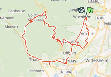

Length
56 km

Max alt
933 m

Uphill gradient
1019 m
Km-Effort
70 km

Min alt
249 m

Downhill gradient
1017 m
Boucle
Yes
Creation date :
2025-05-07 08:02:05.129
Updated on :
2025-05-07 19:13:42.138
5h34
Difficulty : Difficult

FREE GPS app for hiking
 SityTrail
IGN / Geographical institutes
SityTrail Plus
The world is yours!
About
Trail Road bike of 56 km to be discovered at Grand Est, Haut-Rhin, Wuenheim. This trail is proposed by sit68000.
Description
possibilité de manger à la ferme auberge Freundstein ou à la ferme auberge Kohlschlag ou à l'auberge de la Sapinière au niveau du Col Amic.
Positioning
Country:
France
Region :
Grand Est
Department/Province :
Haut-Rhin
Municipality :
Wuenheim
Location:
Unknown
Start:(Dec)
Start:(UTM)
366588 ; 5303850 (32T) N.
Comments