


1
© OpenStreetMap contributors


656h44
Difficulty : Very difficult


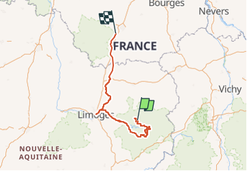
Length
310 km
Max alt
951 m
Uphill gradient
5254 m
Km-Effort
382 km
Min alt
104 m
Downhill gradient
5770 m
Boucle
No
Creation date :
2025-04-02 08:51:47.241
Updated on :
2025-05-10 21:01:50.392
656h44
Difficulty : Very difficult
FREE GPS app for hiking
 SityTrail
IGN / Geographical institutes
SityTrail Plus
The world is yours!
About
Trail Walking of 310 km to be discovered at New Aquitaine, Creuse, Gentioux-Pigerolles. This trail is proposed by Félix RODRIGUEZ VAZQUEZ.
Positioning
Country:
France
Region :
New Aquitaine
Department/Province :
Creuse
Municipality :
Gentioux-Pigerolles
Location:
Unknown
Start:(Dec)
Start:(UTM)
416469 ; 5070053 (31T) N.
Comments