


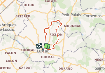
Lussac

Gbreuilh
User

Length
9.6 km

Max alt
78 m

Uphill gradient
108 m
Km-Effort
11.1 km

Min alt
39 m

Downhill gradient
109 m
Boucle
Yes
Creation date :
2025-05-14 07:28:22.897
Updated on :
2025-05-14 10:13:05.639
2h29
Difficulty : Medium

FREE GPS app for hiking
 SityTrail
IGN / Geographical institutes
SityTrail Plus
The world is yours!
About
Trail Walking of 9.6 km to be discovered at New Aquitaine, Gironde, Lussac. This trail is proposed by Gbreuilh.
Positioning
Country:
France
Region :
New Aquitaine
Department/Province :
Gironde
Municipality :
Lussac
Location:
Unknown
Start:(Dec)
Start:(UTM)
729079 ; 4981418 (30T) N.
Comments