


Chapelle Saint Antoine - trace pour SAPAL

611686735
User
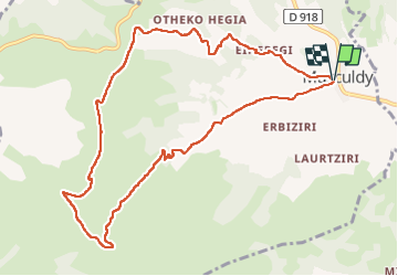

Length
11.6 km

Max alt
700 m

Uphill gradient
520 m
Km-Effort
18.6 km

Min alt
199 m

Downhill gradient
520 m
Boucle
Yes
Creation date :
2025-05-14 08:34:31.0
Updated on :
2025-05-14 19:42:52.983
4h13
Difficulty : Difficult

FREE GPS app for hiking
 SityTrail
IGN / Geographical institutes
SityTrail Plus
The world is yours!
About
Trail Walking of 11.6 km to be discovered at New Aquitaine, Pyrénées-Atlantiques, Musculdy. This trail is proposed by 611686735.
Positioning
Country:
France
Region :
New Aquitaine
Department/Province :
Pyrénées-Atlantiques
Municipality :
Musculdy
Location:
Unknown
Start:(Dec)
Start:(UTM)
665196 ; 4784600 (30T) N.
Comments