


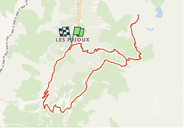
Refuge de la Valette

geoffrayLayeux
User

Length
13.6 km

Max alt
2609 m

Uphill gradient
954 m
Km-Effort
26 km

Min alt
1714 m

Downhill gradient
954 m
Boucle
Yes
Creation date :
2025-05-18 15:29:44.942
Updated on :
2025-05-18 15:30:44.123
5h59
Difficulty : Very difficult

FREE GPS app for hiking
 SityTrail
IGN / Geographical institutes
SityTrail Plus
The world is yours!
About
Trail Walking of 13.6 km to be discovered at Auvergne-Rhône-Alpes, Savoy, Pralognan-la-Vanoise. This trail is proposed by geoffrayLayeux.
Positioning
Country:
France
Region :
Auvergne-Rhône-Alpes
Department/Province :
Savoy
Municipality :
Pralognan-la-Vanoise
Location:
Unknown
Start:(Dec)
Start:(UTM)
319949 ; 5024055 (32T) N.
Comments