


circuit du 19-05-25

dudu79
User
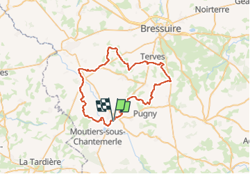

Length
55 km

Max alt
237 m

Uphill gradient
537 m
Km-Effort
62 km

Min alt
150 m

Downhill gradient
533 m
Boucle
Yes
Creation date :
2025-05-19 10:14:09.932
Updated on :
2025-05-19 10:14:38.527
4h19
Difficulty : Very difficult

FREE GPS app for hiking
 SityTrail
IGN / Geographical institutes
SityTrail Plus
The world is yours!
About
Trail Mountain bike of 55 km to be discovered at New Aquitaine, Deux-Sèvres, Moncoutant-sur-Sèvre. This trail is proposed by dudu79.
Positioning
Country:
France
Region :
New Aquitaine
Department/Province :
Deux-Sèvres
Municipality :
Moncoutant-sur-Sèvre
Location:
Moncoutant
Start:(Dec)
Start:(UTM)
684420 ; 5176495 (30T) N.
Comments