


rando du 23-05-2025

dudu79
User

Length
21 km

Max alt
234 m

Uphill gradient
290 m
Km-Effort
25 km

Min alt
175 m

Downhill gradient
289 m
Boucle
Yes
Creation date :
2025-05-22 19:56:35.024
Updated on :
2025-05-22 20:10:40.793
5h37
Difficulty : Very difficult

FREE GPS app for hiking
 SityTrail
IGN / Geographical institutes
SityTrail Plus
The world is yours!
About
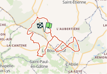
Trail Walking of 21 km to be discovered at New Aquitaine, Deux-Sèvres, Moncoutant-sur-Sèvre. This trail is proposed by dudu79.
Positioning
Country:
France
Region :
New Aquitaine
Department/Province :
Deux-Sèvres
Municipality :
Moncoutant-sur-Sèvre
Location:
La Chapelle-Saint-Étienne
Start:(Dec)
Start:(UTM)
682909 ; 5169967 (30T) N.
Comments