


Sainte Foy

Brigitte Subrenat
User
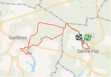

Length
10.8 km

Max alt
107 m

Uphill gradient
102 m
Km-Effort
12.2 km

Min alt
78 m

Downhill gradient
100 m
Boucle
Yes
Creation date :
2025-05-27 12:09:37.897
Updated on :
2025-05-27 15:07:55.011
2h57
Difficulty : Difficult

FREE GPS app for hiking
 SityTrail
IGN / Geographical institutes
SityTrail Plus
The world is yours!
About
Trail Walking of 10.8 km to be discovered at New Aquitaine, Landes, Sainte-Foy. This trail is proposed by Brigitte Subrenat.
Positioning
Country:
France
Region :
New Aquitaine
Department/Province :
Landes
Municipality :
Sainte-Foy
Location:
Unknown
Start:(Dec)
Start:(UTM)
713879 ; 4868513 (30T) N.
Comments