


Col du Hilsenfirst

Alain28/01
User
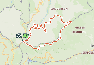

Length
18.1 km

Max alt
1271 m

Uphill gradient
713 m
Km-Effort
28 km

Min alt
738 m

Downhill gradient
714 m
Boucle
Yes
Creation date :
2025-05-28 09:48:48.429
Updated on :
2025-05-28 09:50:04.316
6h17
Difficulty : Difficult

FREE GPS app for hiking
 SityTrail
IGN / Geographical institutes
SityTrail Plus
The world is yours!
About
Trail Walking of 18.1 km to be discovered at Grand Est, Haut-Rhin, Metzeral. This trail is proposed by Alain28/01.
Positioning
Country:
France
Region :
Grand Est
Department/Province :
Haut-Rhin
Municipality :
Metzeral
Location:
Unknown
Start:(Dec)
Start:(UTM)
353160 ; 5312824 (32T) N.
Comments