


Burnhaupt

ROPPJP
User

Length
8.6 km

Max alt
302 m

Uphill gradient
72 m
Km-Effort
9.5 km

Min alt
275 m

Downhill gradient
71 m
Boucle
Yes
Creation date :
2025-05-31 06:49:10.115
Updated on :
2025-05-31 09:00:28.899
2h10
Difficulty : Medium

FREE GPS app for hiking
 SityTrail
IGN / Geographical institutes
SityTrail Plus
The world is yours!
About
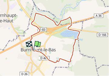
Trail Walking of 8.6 km to be discovered at Grand Est, Haut-Rhin, Burnhaupt-le-Bas. This trail is proposed by ROPPJP.
Photos

Positioning
Country:
France
Region :
Grand Est
Department/Province :
Haut-Rhin
Municipality :
Burnhaupt-le-Bas
Location:
Unknown
Start:(Dec)
Start:(UTM)
362154 ; 5286714 (32T) N.
Comments