


4lacs

LaurentGILG
User
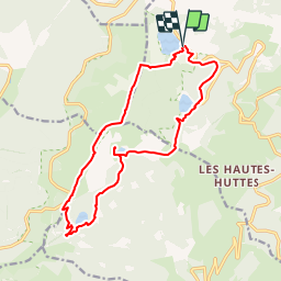

Length
15.8 km

Max alt
1302 m

Uphill gradient
650 m
Km-Effort
24 km

Min alt
952 m

Downhill gradient
645 m
Boucle
Yes
Creation date :
2019-01-20 20:50:40.085
Updated on :
2019-01-20 20:50:40.142
5h12
Difficulty : Difficult

FREE GPS app for hiking
 SityTrail
IGN / Geographical institutes
SityTrail Plus
The world is yours!
About
Trail Walking of 15.8 km to be discovered at Grand Est, Haut-Rhin, Orbey. This trail is proposed by LaurentGILG.
Photos


Points of interest


Positioning
Country:
France
Region :
Grand Est
Department/Province :
Haut-Rhin
Municipality :
Orbey
Location:
Unknown
Start:(Dec)
Start:(UTM)
358314 ; 5331961 (32U) N.
Comments
très jolie parcour avec de belles vues...
très jolie parcour avec de belles vues...