


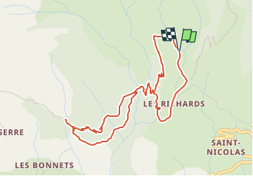
La cascade des Richards

ARPF
User

Length
5.8 km

Max alt
1643 m

Uphill gradient
352 m
Km-Effort
10.5 km

Min alt
1323 m

Downhill gradient
342 m
Boucle
Yes
Creation date :
2025-06-04 15:00:25.407
Updated on :
2025-06-07 14:01:11.529
2h22
Difficulty : Medium

FREE GPS app for hiking
 SityTrail
IGN / Geographical institutes
SityTrail Plus
The world is yours!
About
Trail Walking of 5.8 km to be discovered at Provence-Alpes-Côte d'Azur, Hautes-Alpes, Saint-Jean-Saint-Nicolas. This trail is proposed by ARPF.

Positioning
Country:
France
Region :
Provence-Alpes-Côte d'Azur
Department/Province :
Hautes-Alpes
Municipality :
Saint-Jean-Saint-Nicolas
Location:
Unknown
Start:(Dec)
Start:(UTM)
280763 ; 4951883 (32T) N.
Comments