


Gr78 stcolome-ogeu 2025

LouisROGER
User GUIDE
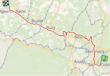

Length
15.2 km

Max alt
571 m

Uphill gradient
240 m
Km-Effort
19.1 km

Min alt
319 m

Downhill gradient
460 m
Boucle
No
Creation date :
2025-06-06 06:42:16.116
Updated on :
2025-06-06 13:59:02.262
7h16
Difficulty : Very difficult

FREE GPS app for hiking
 SityTrail
IGN / Geographical institutes
SityTrail Plus
The world is yours!
About
Trail Walking of 15.2 km to be discovered at New Aquitaine, Pyrénées-Atlantiques, Sainte-Colome. This trail is proposed by LouisROGER.
Photos


Positioning
Country:
France
Region :
New Aquitaine
Department/Province :
Pyrénées-Atlantiques
Municipality :
Sainte-Colome
Location:
Unknown
Start:(Dec)
Start:(UTM)
711223 ; 4775400 (30T) N.
Comments