


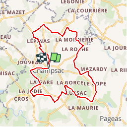
Champsac sentier des puits

dchauprade
User

Length
18.6 km

Max alt
396 m

Uphill gradient
288 m
Km-Effort
22 km

Min alt
292 m

Downhill gradient
288 m
Boucle
Yes
Creation date :
2015-07-23 00:00:00.0
Updated on :
2015-07-23 00:00:00.0
5h13
Difficulty : Medium

FREE GPS app for hiking
 SityTrail
IGN / Geographical institutes
SityTrail Plus
The world is yours!
About
Trail Walking of 18.6 km to be discovered at New Aquitaine, Haute-Vienne, Champsac. This trail is proposed by dchauprade.
Description
Rando un peu longue autour de Champsac (87), beaucoup de passage à l'ombre dans des chemins creux ou sous bois.
Positioning
Country:
France
Region :
New Aquitaine
Department/Province :
Haute-Vienne
Municipality :
Champsac
Location:
Unknown
Start:(Dec)
Start:(UTM)
340939 ; 5062972 (31T) N.
Comments