


Gr 36 villebois Lavalette

taguette
User
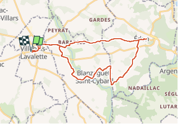

Length
18.8 km

Max alt
190 m

Uphill gradient
331 m
Km-Effort
23 km

Min alt
94 m

Downhill gradient
334 m
Boucle
Yes
Creation date :
2025-06-08 12:37:34.161
Updated on :
2025-06-08 16:36:52.574
3h58
Difficulty : Very difficult

FREE GPS app for hiking
 SityTrail
IGN / Geographical institutes
SityTrail Plus
The world is yours!
About
Trail Walking of 18.8 km to be discovered at New Aquitaine, Charente, Villebois-Lavalette. This trail is proposed by taguette.
Positioning
Country:
France
Region :
New Aquitaine
Department/Province :
Charente
Municipality :
Villebois-Lavalette
Location:
Unknown
Start:(Dec)
Start:(UTM)
287214 ; 5040102 (31T) N.
Comments