


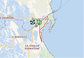
Port Royer

viam19
User

Length
4.3 km

Max alt
8 m

Uphill gradient
20 m
Km-Effort
4.5 km

Min alt
0 m

Downhill gradient
20 m
Boucle
Yes
Creation date :
2025-06-11 21:44:35.981
Updated on :
2025-06-11 21:45:18.342
1h02
Difficulty : Easy

FREE GPS app for hiking
 SityTrail
IGN / Geographical institutes
SityTrail Plus
The world is yours!
About
Trail Walking of 4.3 km to be discovered at New Aquitaine, Charente-Maritime, Saint-Pierre-d'Oléron. This trail is proposed by viam19.
Positioning
Country:
France
Region :
New Aquitaine
Department/Province :
Charente-Maritime
Municipality :
Saint-Pierre-d'Oléron
Location:
Unknown
Start:(Dec)
Start:(UTM)
635898 ; 5091309 (30T) N.
Comments