


Vercors pas de l’Essaurt pas de l’Aiguille

c.gourme
User
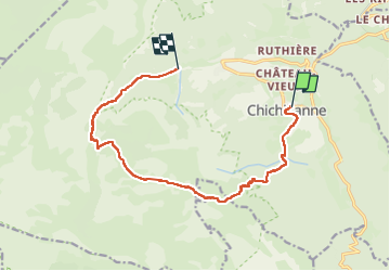

Length
13.3 km

Max alt
1845 m

Uphill gradient
866 m
Km-Effort
24 km

Min alt
980 m

Downhill gradient
754 m
Boucle
No
Creation date :
2025-06-10 08:11:05.0
Updated on :
2025-06-12 11:50:36.317
5h14
Difficulty : Medium

FREE GPS app for hiking
 SityTrail
IGN / Geographical institutes
SityTrail Plus
The world is yours!
About
Trail Walking of 13.3 km to be discovered at Auvergne-Rhône-Alpes, Isère, Chichilianne. This trail is proposed by c.gourme.
Positioning
Country:
France
Region :
Auvergne-Rhône-Alpes
Department/Province :
Isère
Municipality :
Chichilianne
Location:
Unknown
Start:(Dec)
Start:(UTM)
703633 ; 4965317 (31T) N.
Comments