


Lanslevillard > lac de l'Arcelle > Col du Mont Cenis

catduv
User
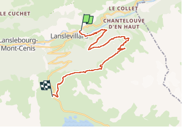

Length
13.8 km

Max alt
2297 m

Uphill gradient
915 m
Km-Effort
24 km

Min alt
1474 m

Downhill gradient
313 m
Boucle
No
Creation date :
2025-06-10 07:11:32.356
Updated on :
2025-06-12 15:00:36.162
4h06
Difficulty : Medium

FREE GPS app for hiking
 SityTrail
IGN / Geographical institutes
SityTrail Plus
The world is yours!
About
Trail Walking of 13.8 km to be discovered at Auvergne-Rhône-Alpes, Savoy, Val-Cenis. This trail is proposed by catduv.
Positioning
Country:
France
Region :
Auvergne-Rhône-Alpes
Department/Province :
Savoy
Municipality :
Val-Cenis
Location:
Lanslevillard
Start:(Dec)
Start:(UTM)
336853 ; 5017456 (32T) N.
Comments