


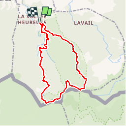
SOREDE 66 - la vallée heureuse - GR10 puis gorges du TASSIO au retour

jeff66
User


6h12
Difficulty : Very difficult

FREE GPS app for hiking
 SityTrail
IGN / Geographical institutes
SityTrail Plus
The world is yours!
About
Trail Walking of 21 km to be discovered at Occitania, Pyrénées-Orientales, Sorède. This trail is proposed by jeff66.
Description
SOREDE 66 - la vallée heureuse - départ de la Farge - traverser le long du barrage le lit de la rivière sur les galets - rampe côté opposé - sous bois - l'entrée en matière est sévère plus calme ensuite .... - vides sur la vallée heureuse la plaine les Corbières - au panneau Roc Médes à gauche le sentier grimpe en lacets - Roc de Les Médes - tout droit en direction de font Del Miracles - hêtraies et cheneraies - suivre balisage bleu - Puig DELS Fornets - col de l'Aranyo - rivière l'Aranyo - col des 3 hêtres - panorama sur collioure la cote la tour Madeloc - forêt domaniale des Albères - Els camp Del soldats - magnifique forêt de hêtres - GR10 - col des émigrants - Paratje natural d'interes nacional de l'Albera - coll de l'Estaca - borne 586 - Rasos de la Menta - col de las Mosqueres - collada del L'Orri - la Foun del l'Orry - descente en longeant le ruisseau correc de la Tassio et correc de les Mosqueres - passage d'une berge a l'autre le long des cascades et piscines naturelles - hêtraies - passage dans un petit canyon sec - châtaigneraie - sous bois diverses essences - collada de l'Espinas - la Farge - ITIERAIRE AVEC QUELQUES PASSAGES RAIDES JUSQU'AU GR10 LA DESCENTE EST TECHNIQUE ET PHYSIQUE A NE PAS FAIRE PAR TEMPS DE PLUIE OU D'ORAGE PREFERER ALORS LA PISTE
Photos


55 photos in total. Please click on a photo to see them all in the gallery.
Positioning
Comments