


Rs Lucgarier 2025

LouisROGER
User GUIDE
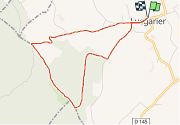

Length
5 km

Max alt
428 m

Uphill gradient
115 m
Km-Effort
6.6 km

Min alt
314 m

Downhill gradient
115 m
Boucle
Yes
Creation date :
2025-06-17 12:02:14.933
Updated on :
2025-06-17 14:13:50.618
2h10
Difficulty : Medium

FREE GPS app for hiking
 SityTrail
IGN / Geographical institutes
SityTrail Plus
The world is yours!
About
Trail Walking of 5 km to be discovered at New Aquitaine, Pyrénées-Atlantiques, Lucgarier. This trail is proposed by LouisROGER.
Positioning
Country:
France
Region :
New Aquitaine
Department/Province :
Pyrénées-Atlantiques
Municipality :
Lucgarier
Location:
Unknown
Start:(Dec)
Start:(UTM)
727992 ; 4790951 (30T) N.
Comments