


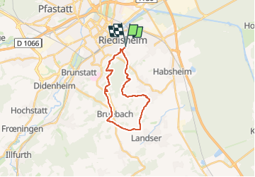
Riedisheim Bruebach Landser

Alain28/01
User

Length
19.6 km

Max alt
364 m

Uphill gradient
391 m
Km-Effort
25 km

Min alt
248 m

Downhill gradient
391 m
Boucle
Yes
Creation date :
2025-06-17 20:30:59.971
Updated on :
2025-06-17 20:32:28.854
5h37
Difficulty : Medium

FREE GPS app for hiking
 SityTrail
IGN / Geographical institutes
SityTrail Plus
The world is yours!
About
Trail On foot of 19.6 km to be discovered at Grand Est, Haut-Rhin, Riedisheim. This trail is proposed by Alain28/01.
Positioning
Country:
France
Region :
Grand Est
Department/Province :
Haut-Rhin
Municipality :
Riedisheim
Location:
Unknown
Start:(Dec)
Start:(UTM)
377900 ; 5289180 (32T) N.
Comments