


Sortie velo le Mont Lachat

choubaka77
User
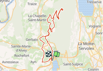

Length
41 km

Max alt
1493 m

Uphill gradient
1663 m
Km-Effort
63 km

Min alt
382 m

Downhill gradient
1662 m
Boucle
Yes
Creation date :
2025-06-18 08:24:28.039
Updated on :
2025-06-18 08:26:57.455
3h50
Difficulty : Very difficult

FREE GPS app for hiking
 SityTrail
IGN / Geographical institutes
SityTrail Plus
The world is yours!
About
Trail Road bike of 41 km to be discovered at Auvergne-Rhône-Alpes, Savoy, Nances. This trail is proposed by choubaka77.
Positioning
Country:
France
Region :
Auvergne-Rhône-Alpes
Department/Province :
Savoy
Municipality :
Nances
Location:
Unknown
Start:(Dec)
Start:(UTM)
718183 ; 5050468 (31T) N.
Comments