


Les 18km de St Pardoux

jvignaud
User
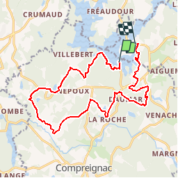

Length
17.7 km

Max alt
447 m

Uphill gradient
414 m
Km-Effort
23 km

Min alt
342 m

Downhill gradient
402 m
Boucle
No
Creation date :
2014-12-10 00:00:00.0
Updated on :
2014-12-10 00:00:00.0
5h51
Difficulty : Unknown

FREE GPS app for hiking
 SityTrail
IGN / Geographical institutes
SityTrail Plus
The world is yours!
About
Trail Walking of 17.7 km to be discovered at New Aquitaine, Haute-Vienne, Compreignac. This trail is proposed by jvignaud.
Positioning
Country:
France
Region :
New Aquitaine
Department/Province :
Haute-Vienne
Municipality :
Compreignac
Location:
Unknown
Start:(Dec)
Start:(UTM)
367843 ; 5098602 (31T) N.
Comments