


Rando des Marcheurs 20/05/2025

boubou68
User

Length
19.9 km

Max alt
364 m

Uphill gradient
385 m
Km-Effort
25 km

Min alt
249 m

Downhill gradient
385 m
Boucle
Yes
Creation date :
2025-06-20 05:07:38.889
Updated on :
2025-06-20 10:04:40.898
4h13
Difficulty : Difficult

FREE GPS app for hiking
 SityTrail
IGN / Geographical institutes
SityTrail Plus
The world is yours!
About
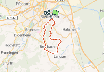
Trail Walking of 19.9 km to be discovered at Grand Est, Haut-Rhin, Riedisheim. This trail is proposed by boubou68.
Description
C'est tellement agréable de randonner en toute amitié avec les copains même sur un itinéraire sans "intérêt ".!
Photos


Positioning
Country:
France
Region :
Grand Est
Department/Province :
Haut-Rhin
Municipality :
Riedisheim
Location:
Unknown
Start:(Dec)
Start:(UTM)
377877 ; 5289192 (32T) N.
Comments