


Pointe de tierce reco

Michel_Martin
User
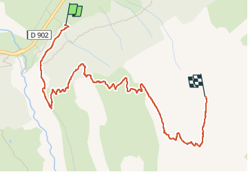

Length
4.8 km

Max alt
2958 m

Uphill gradient
1206 m
Km-Effort
16.9 km

Min alt
1746 m

Downhill gradient
2 m
Boucle
No
Creation date :
2025-06-18 05:56:03.644
Updated on :
2025-08-07 13:57:43.07
2h15
Difficulty : Medium

FREE GPS app for hiking
 SityTrail
IGN / Geographical institutes
SityTrail Plus
The world is yours!
About
Trail Walking of 4.8 km to be discovered at Auvergne-Rhône-Alpes, Savoy, Bessans. This trail is proposed by Michel_Martin.
Positioning
Country:
France
Region :
Auvergne-Rhône-Alpes
Department/Province :
Savoy
Municipality :
Bessans
Location:
Unknown
Start:(Dec)
Start:(UTM)
342887 ; 5019854 (32T) N.
Comments