


rs Issor

LouisROGER
User GUIDE
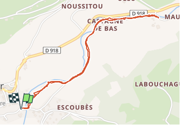

Length
2.9 km

Max alt
309 m

Uphill gradient
27 m
Km-Effort
3.3 km

Min alt
295 m

Downhill gradient
27 m
Boucle
Yes
Creation date :
2025-06-24 08:01:54.632
Updated on :
2025-06-24 09:48:52.123
1h46
Difficulty : Easy

FREE GPS app for hiking
 SityTrail
IGN / Geographical institutes
SityTrail Plus
The world is yours!
About
Trail Walking of 2.9 km to be discovered at New Aquitaine, Pyrénées-Atlantiques, Issor. This trail is proposed by LouisROGER.
Positioning
Country:
France
Region :
New Aquitaine
Department/Province :
Pyrénées-Atlantiques
Municipality :
Issor
Location:
Unknown
Start:(Dec)
Start:(UTM)
690476 ; 4774551 (30T) N.
Comments