


l aiguillon

josiane cesare
User
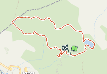

Length
5.8 km

Max alt
2076 m

Uphill gradient
235 m
Km-Effort
9 km

Min alt
1843 m

Downhill gradient
246 m
Boucle
Yes
Creation date :
2025-06-25 06:33:32.843
Updated on :
2025-06-25 06:33:34.889
2h02
Difficulty : Medium

FREE GPS app for hiking
 SityTrail
IGN / Geographical institutes
SityTrail Plus
The world is yours!
About
Trail Walking of 5.8 km to be discovered at Provence-Alpes-Côte d'Azur, Hautes-Alpes, Villar-d'Arêne. This trail is proposed by josiane cesare.
Positioning
Country:
France
Region :
Provence-Alpes-Côte d'Azur
Department/Province :
Hautes-Alpes
Municipality :
Villar-d'Arêne
Location:
Unknown
Start:(Dec)
Start:(UTM)
291031 ; 4991766 (32T) N.
Comments