


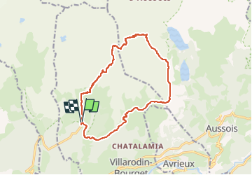
départ parking refuge de l'orgere

gerardmicheline
User

Length
15.7 km

Max alt
2921 m

Uphill gradient
1179 m
Km-Effort
31 km

Min alt
1860 m

Downhill gradient
1188 m
Boucle
Yes
Creation date :
2025-06-27 12:59:51.575
Updated on :
2025-06-27 13:01:10.592
7h08
Difficulty : Very difficult

FREE GPS app for hiking
 SityTrail
IGN / Geographical institutes
SityTrail Plus
The world is yours!
About
Trail Walking of 15.7 km to be discovered at Auvergne-Rhône-Alpes, Savoy, Villarodin-Bourget. This trail is proposed by gerardmicheline.
Positioning
Country:
France
Region :
Auvergne-Rhône-Alpes
Department/Province :
Savoy
Municipality :
Villarodin-Bourget
Location:
Unknown
Start:(Dec)
Start:(UTM)
317323 ; 5011134 (32T) N.
Comments