


repas champêtre 2025

waggy
User
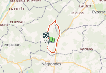

Length
7 km

Max alt
245 m

Uphill gradient
107 m
Km-Effort
8.4 km

Min alt
179 m

Downhill gradient
94 m
Boucle
No
Creation date :
2025-06-29 06:51:09.072
Updated on :
2025-06-29 08:25:47.324
1h34
Difficulty : Easy

FREE GPS app for hiking
 SityTrail
IGN / Geographical institutes
SityTrail Plus
The world is yours!
About
Trail Walking of 7 km to be discovered at New Aquitaine, Dordogne, Vaunac. This trail is proposed by waggy.
Positioning
Country:
France
Region :
New Aquitaine
Department/Province :
Dordogne
Municipality :
Vaunac
Location:
Unknown
Start:(Dec)
Start:(UTM)
332436 ; 5025149 (31T) N.
Comments