


canigou

mthomas30
User
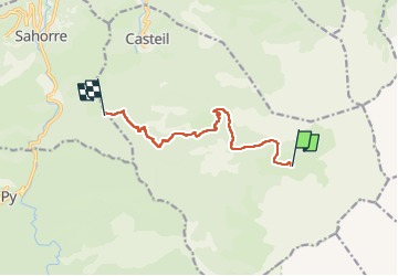

Length
9.1 km

Max alt
2079 m

Uphill gradient
183 m
Km-Effort
14.6 km

Min alt
1124 m

Downhill gradient
1104 m
Boucle
No
Creation date :
2025-06-27 08:17:48.458
Updated on :
2025-07-01 07:54:33.488
2h47
Difficulty : Difficult

FREE GPS app for hiking
 SityTrail
IGN / Geographical institutes
SityTrail Plus
The world is yours!
About
Trail Walking of 9.1 km to be discovered at Occitania, Pyrénées-Orientales, Casteil. This trail is proposed by mthomas30.
Positioning
Country:
France
Region :
Occitania
Department/Province :
Pyrénées-Orientales
Municipality :
Casteil
Location:
Unknown
Start:(Dec)
Start:(UTM)
453900 ; 4705760 (31T) N.
Comments