


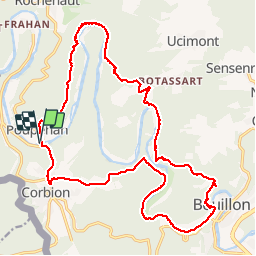
Poupehan_Bouillon tour

mavbelgium
User


7h13
Difficulty : Difficult

FREE GPS app for hiking
 SityTrail
IGN / Geographical institutes
SityTrail Plus
The world is yours!
About
Trail Walking of 23 km to be discovered at Wallonia, Luxembourg, Bouillon. This trail is proposed by mavbelgium.
Description
voorbereiding GR20. Start pittig in Poupehan.. langs Semois Ri Tombe du Geant en Bouillon. Terug langs andere oever van Semois naar Corbion en Poupehan. Veel hoogtemeters.. lekker stevige wandeling
Photos


36 photos in total. Please click on a photo to see them all in the gallery.
Positioning
Comments