


St Etienne de baigorry Bidaray

viaul
User GUIDE
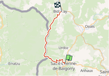

Length
18.9 km

Max alt
1036 m

Uphill gradient
1235 m
Km-Effort
35 km

Min alt
138 m

Downhill gradient
1247 m
Boucle
No
Creation date :
2025-07-08 05:12:20.0
Updated on :
2025-07-08 15:49:29.718
7h26
Difficulty : Very difficult

FREE GPS app for hiking
 SityTrail
IGN / Geographical institutes
SityTrail Plus
The world is yours!
About
Trail Walking of 18.9 km to be discovered at New Aquitaine, Pyrénées-Atlantiques, Saint-Étienne-de-Baïgorry. This trail is proposed by viaul.
Description
Rando très physique
Positioning
Country:
France
Region :
New Aquitaine
Department/Province :
Pyrénées-Atlantiques
Municipality :
Saint-Étienne-de-Baïgorry
Location:
Unknown
Start:(Dec)
Start:(UTM)
634928 ; 4782028 (30T) N.
Comments