


gr5 J1

yvesconnes
User
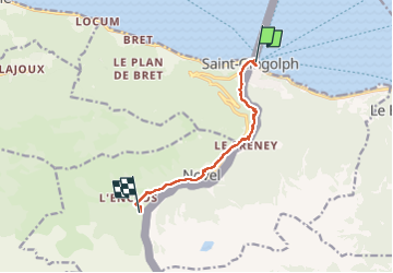

Length
7.3 km

Max alt
1229 m

Uphill gradient
850 m
Km-Effort
15.8 km

Min alt
375 m

Downhill gradient
4 m
Boucle
No
Creation date :
2025-07-09 14:19:26.89
Updated on :
2025-07-10 09:25:58.794
2h35
Difficulty : Difficult

FREE GPS app for hiking
 SityTrail
IGN / Geographical institutes
SityTrail Plus
The world is yours!
About
Trail Walking of 7.3 km to be discovered at Valais/Wallis, Monthey, Saint-Gingolph. This trail is proposed by yvesconnes.
Positioning
Country:
Switzerland
Region :
Valais/Wallis
Department/Province :
Monthey
Municipality :
Saint-Gingolph
Location:
Unknown
Start:(Dec)
Start:(UTM)
331296 ; 5140098 (32T) N.
Comments