


Olhette henday

viaul
User GUIDE

Length
23 km

Max alt
529 m

Uphill gradient
972 m
Km-Effort
36 km

Min alt
0 m

Downhill gradient
1069 m
Boucle
No
Creation date :
2025-07-11 05:44:36.0
Updated on :
2025-07-11 15:18:26.478
6h50
Difficulty : Very difficult

FREE GPS app for hiking
 SityTrail
IGN / Geographical institutes
SityTrail Plus
The world is yours!
About
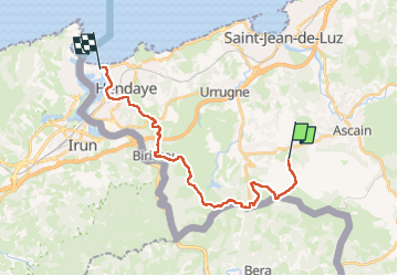
Trail Walking of 23 km to be discovered at New Aquitaine, Pyrénées-Atlantiques, Urrugne. This trail is proposed by viaul.
Positioning
Country:
France
Region :
New Aquitaine
Department/Province :
Pyrénées-Atlantiques
Municipality :
Urrugne
Location:
Unknown
Start:(Dec)
Start:(UTM)
608629 ; 4798551 (30T) N.
Comments