


25 07 12

jmbilger
User
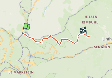

Length
8.2 km

Max alt
1252 m

Uphill gradient
62 m
Km-Effort
10.4 km

Min alt
823 m

Downhill gradient
477 m
Boucle
No
Creation date :
2025-07-12 12:54:45.0
Updated on :
2025-07-12 14:53:41.281
1h44
Difficulty : Unknown

FREE GPS app for hiking
 SityTrail
IGN / Geographical institutes
SityTrail Plus
The world is yours!
About
Trail Walking of 8.2 km to be discovered at Grand Est, Haut-Rhin, Metzeral. This trail is proposed by jmbilger.
Description
Col oberlauchauchen Obersengern
Positioning
Country:
France
Region :
Grand Est
Department/Province :
Haut-Rhin
Municipality :
Metzeral
Location:
Unknown
Start:(Dec)
Start:(UTM)
353184 ; 5312812 (32T) N.
Comments