


Thues les Bains Les Sources

oscar1
User

Length
4.8 km

Max alt
875 m

Uphill gradient
179 m
Km-Effort
7.2 km

Min alt
787 m

Downhill gradient
200 m
Boucle
Yes
Creation date :
2025-07-13 12:46:39.365
Updated on :
2025-07-22 13:53:04.316
1h40
Difficulty : Medium

FREE GPS app for hiking
 SityTrail
IGN / Geographical institutes
SityTrail Plus
The world is yours!
About
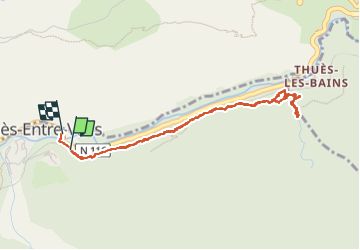
Trail Walking of 4.8 km to be discovered at Occitania, Pyrénées-Orientales, Thuès-Entre-Valls. This trail is proposed by oscar1.
Photos


Positioning
Country:
France
Region :
Occitania
Department/Province :
Pyrénées-Orientales
Municipality :
Thuès-Entre-Valls
Location:
Unknown
Start:(Dec)
Start:(UTM)
436490 ; 4708270 (31T) N.
Comments