


lac vert

JPS73
User
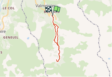

Length
10.6 km

Max alt
2000 m

Uphill gradient
386 m
Km-Effort
15.8 km

Min alt
1643 m

Downhill gradient
384 m
Boucle
Yes
Creation date :
2025-07-18 07:53:23.875
Updated on :
2025-07-18 12:35:57.038
3h17
Difficulty : Difficult

FREE GPS app for hiking
 SityTrail
IGN / Geographical institutes
SityTrail Plus
The world is yours!
About
Trail Walking of 10.6 km to be discovered at Auvergne-Rhône-Alpes, Savoy, Valmeinier. This trail is proposed by JPS73.
Positioning
Country:
France
Region :
Auvergne-Rhône-Alpes
Department/Province :
Savoy
Municipality :
Valmeinier
Location:
Unknown
Start:(Dec)
Start:(UTM)
302684 ; 5005699 (32T) N.
Comments