


st amarin-markstein- edelweiss

chantalwaltzer
User
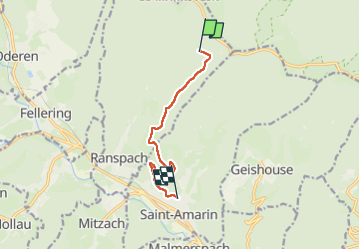

Length
7.1 km

Max alt
913 m

Uphill gradient
76 m
Km-Effort
9.6 km

Min alt
422 m

Downhill gradient
538 m
Boucle
No
Creation date :
2025-07-18 11:10:07.0
Updated on :
2025-07-18 12:47:21.489
1h36
Difficulty : Medium

FREE GPS app for hiking
 SityTrail
IGN / Geographical institutes
SityTrail Plus
The world is yours!
About
Trail Walking of 7.1 km to be discovered at Grand Est, Haut-Rhin, Ranspach. This trail is proposed by chantalwaltzer.
Description
diffficile
Positioning
Country:
France
Region :
Grand Est
Department/Province :
Haut-Rhin
Municipality :
Ranspach
Location:
Unknown
Start:(Dec)
Start:(UTM)
353447 ; 5308242 (32T) N.
Comments