


Beaufortain Queige lac des Saisies

taguette
User
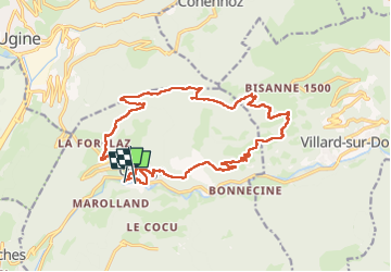

Length
20 km

Max alt
1678 m

Uphill gradient
1268 m
Km-Effort
37 km

Min alt
527 m

Downhill gradient
1261 m
Boucle
No
Creation date :
2025-07-14 06:22:39.791
Updated on :
2025-07-18 17:05:54.321
8h04
Difficulty : Very difficult

FREE GPS app for hiking
 SityTrail
IGN / Geographical institutes
SityTrail Plus
The world is yours!
About
Trail Walking of 20 km to be discovered at Auvergne-Rhône-Alpes, Savoy, Queige. This trail is proposed by taguette.
Positioning
Country:
France
Region :
Auvergne-Rhône-Alpes
Department/Province :
Savoy
Municipality :
Queige
Location:
Unknown
Start:(Dec)
Start:(UTM)
301870 ; 5065779 (32T) N.
Comments