


bramans

JPS73
User
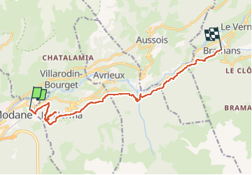

Length
12.8 km

Max alt
1417 m

Uphill gradient
506 m
Km-Effort
19.2 km

Min alt
1126 m

Downhill gradient
379 m
Boucle
No
Creation date :
2025-07-22 06:38:43.369
Updated on :
2025-07-22 13:02:06.714
3h55
Difficulty : Very difficult

FREE GPS app for hiking
 SityTrail
IGN / Geographical institutes
SityTrail Plus
The world is yours!
About
Trail Walking of 12.8 km to be discovered at Auvergne-Rhône-Alpes, Savoy, Modane. This trail is proposed by JPS73.
Positioning
Country:
France
Region :
Auvergne-Rhône-Alpes
Department/Province :
Savoy
Municipality :
Modane
Location:
Unknown
Start:(Dec)
Start:(UTM)
317916 ; 5008133 (32T) N.
Comments