


25 07 22 VTM

jmbilger
User
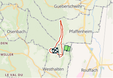

Length
8.2 km

Max alt
506 m

Uphill gradient
266 m
Km-Effort
11.9 km

Min alt
319 m

Downhill gradient
292 m
Boucle
No
Creation date :
2025-07-22 12:09:12.0
Updated on :
2025-07-22 15:39:08.725
2h25
Difficulty : Unknown

FREE GPS app for hiking
 SityTrail
IGN / Geographical institutes
SityTrail Plus
The world is yours!
About
Trail Walking of 8.2 km to be discovered at Grand Est, Haut-Rhin, Westhalten. This trail is proposed by jmbilger.
Positioning
Country:
France
Region :
Grand Est
Department/Province :
Haut-Rhin
Municipality :
Westhalten
Location:
Unknown
Start:(Dec)
Start:(UTM)
370904 ; 5314166 (32T) N.
Comments