


col du Souffre

geoffrayLayeux
User
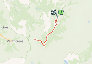

Length
22 km

Max alt
2819 m

Uphill gradient
1223 m
Km-Effort
39 km

Min alt
1738 m

Downhill gradient
1223 m
Boucle
Yes
Creation date :
2025-07-22 16:28:53.876
Updated on :
2025-07-22 16:29:30.753
8h46
Difficulty : Very difficult

FREE GPS app for hiking
 SityTrail
IGN / Geographical institutes
SityTrail Plus
The world is yours!
About
Trail Walking of 22 km to be discovered at Auvergne-Rhône-Alpes, Savoy, Pralognan-la-Vanoise. This trail is proposed by geoffrayLayeux.
Positioning
Country:
France
Region :
Auvergne-Rhône-Alpes
Department/Province :
Savoy
Municipality :
Pralognan-la-Vanoise
Location:
Unknown
Start:(Dec)
Start:(UTM)
319488 ; 5023475 (32T) N.
Comments