


pleynet correncon

sabine38
User

Length
15.7 km

Max alt
1977 m

Uphill gradient
844 m
Km-Effort
27 km

Min alt
1143 m

Downhill gradient
844 m
Boucle
Yes
Creation date :
2025-07-24 07:09:49.11
Updated on :
2025-07-24 14:56:07.04
7h41
Difficulty : Difficult

FREE GPS app for hiking
 SityTrail
IGN / Geographical institutes
SityTrail Plus
The world is yours!
About
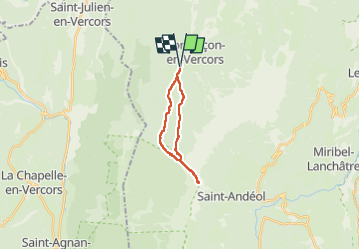
Trail Walking of 15.7 km to be discovered at Auvergne-Rhône-Alpes, Isère, Corrençon-en-Vercors. This trail is proposed by sabine38.
Positioning
Country:
France
Region :
Auvergne-Rhône-Alpes
Department/Province :
Isère
Municipality :
Corrençon-en-Vercors
Location:
Unknown
Start:(Dec)
Start:(UTM)
698354 ; 4988754 (31T) N.
Comments