


Chamaloc.07

pikibangi
User
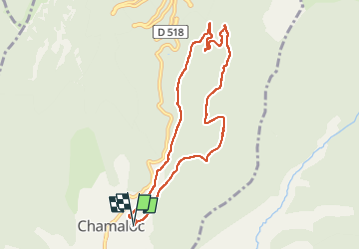

Length
8.4 km

Max alt
807 m

Uphill gradient
274 m
Km-Effort
12.1 km

Min alt
538 m

Downhill gradient
273 m
Boucle
Yes
Creation date :
2025-07-25 06:45:23.119
Updated on :
2025-07-25 08:27:16.734
1h33
Difficulty : Very easy

FREE GPS app for hiking
 SityTrail
IGN / Geographical institutes
SityTrail Plus
The world is yours!
About
Trail Nordic walking of 8.4 km to be discovered at Auvergne-Rhône-Alpes, Drôme, Chamaloc. This trail is proposed by pikibangi.
Positioning
Country:
France
Region :
Auvergne-Rhône-Alpes
Department/Province :
Drôme
Municipality :
Chamaloc
Location:
Unknown
Start:(Dec)
Start:(UTM)
688866 ; 4963362 (31T) N.
Comments