


gta jour 16

yvesconnes
User
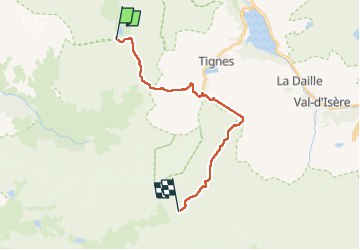

Length
18.9 km

Max alt
2745 m

Uphill gradient
1191 m
Km-Effort
34 km

Min alt
2107 m

Downhill gradient
871 m
Boucle
No
Creation date :
2025-07-24 05:58:10.356
Updated on :
2025-07-26 13:29:24.248
4h30
Difficulty : Difficult

FREE GPS app for hiking
 SityTrail
IGN / Geographical institutes
SityTrail Plus
The world is yours!
About
Trail Walking of 18.9 km to be discovered at Auvergne-Rhône-Alpes, Savoy, Peisey-Nancroix. This trail is proposed by yvesconnes.
Positioning
Country:
France
Region :
Auvergne-Rhône-Alpes
Department/Province :
Savoy
Municipality :
Peisey-Nancroix
Location:
Unknown
Start:(Dec)
Start:(UTM)
331101 ; 5038603 (32T) N.
Comments