Trail Walking Massiac - Hike 318 jour 1 - Photo
© OpenStreetMap contributors
Length
Length
24 km
Max alt
Max alt
1055 m
Uphill gradient
Uphill gradient
915 m
Km-Effort
Km-Effort  
36 km
Min alt
Min alt
538 m
Downhill gradient
Downhill gradient
788 m
Boucle
Boucle
No
Creation date :
2015-08-03 00:00:00.0
Updated on :
2015-08-03 00:00:00.0

(0 Reviews)

Walking
Walking
6h45
Difficulty : Medium

Scan this QR Code to open this trail in the SityTrail application

FREE GPS app for hiking

Logo SityTrail SityTrail

IGN / Geographical institutes

Download SityTrail from the App Store Download SityTrail from Google Play

Logo SityTrail SityTrail World

The world is yours!

Download SityTrail from the App Store Download SityTrail from Google Play Download SityTrail on Huawei AppGallery

About

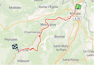
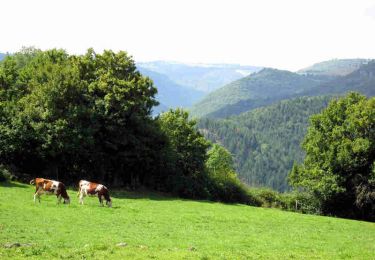
Trail Walking of 24 km to be discovered at Auvergne-Rhône-Alpes, Cantal, Massiac. This trail is proposed by albert318.

Description

Molompize - Ferrière saint mary

Elevation profile

Photos

Points of interest

Positioning

Country:
France
Region :
Auvergne-Rhône-Alpes
Department/Province :
Cantal
Municipality :
Massiac
Location:
Unknown
Start:(UTM)
515473 ; 5011029 (31T) N.

Trails nearby

Trail Walking Massiac - Massiac_Ste_Madeleine - Photo
Walking
GUIDE
jagarnier

Walking

Medium
Massiac, Auvergne-Rhône-Alpes, Cantal, France
12 km | 17.4 km-effort
3h 30min
Yes
Trail Walking Massiac - Massiac_Chateau_Aurouze - Photo
Walking
GUIDE
jagarnier

Walking

Medium
Massiac, Auvergne-Rhône-Alpes, Cantal, France
13 km | 18.1 km-effort
4h 0min
Yes
Trail Walking Massiac - La Via Arverna (Massiac  - Ferrières Saint Mary) - Photo
Walking
tracegps

Walking

Difficult
Massiac, Auvergne-Rhône-Alpes, Cantal, France
24 km | 36 km-effort
6h 45min
No
Trail 4x4 Massiac - Massiac 2021 1er jour - Photo
4x4
pb32

4x4

Medium
Massiac, Auvergne-Rhône-Alpes, Cantal, France
133 km | 180 km-effort
8h 18min
No
Trail Walking Massiac - Chapelle Sainte Madeleine à Massiac  - Photo
Walking
Pat_83200

Walking

Difficult
Massiac, Auvergne-Rhône-Alpes, Cantal, France
9.3 km | 12.4 km-effort
2h 42min
Yes
Trail Mountain bike Massiac - Rando Massiac - Photo
Mountain bike
adsp63

Mountain bike

Very difficult
Massiac, Auvergne-Rhône-Alpes, Cantal, France
37 km | 49 km-effort
3h 9min
Yes
Trail Walking Massiac - 00594 - La Chapelle Sainte Madeleine - Photo
Walking
betf

Walking

Difficult
Massiac, Auvergne-Rhône-Alpes, Cantal, France
11.9 km | 17.3 km-effort
3h 37min
Yes
Trail Walking Massiac - Massiac - Photo
Walking
betf

Walking

Difficult
Massiac, Auvergne-Rhône-Alpes, Cantal, France
10.8 km | 15.5 km-effort
3h 25min
Yes
Trail Motorbike Massiac - Massiac saint flour - Photo
Motorbike
jaboin

Motorbike

Massiac, Auvergne-Rhône-Alpes, Cantal, France
59 km | 81 km-effort
1h 43min
No


Close
My subscriptions