


Reconnaissance, Saint Denis dâOléron

ezola
User
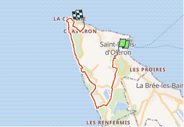

Length
11.4 km

Max alt
11 m

Uphill gradient
53 m
Km-Effort
12.1 km

Min alt
-1 m

Downhill gradient
48 m
Boucle
No
Creation date :
2025-07-27 09:06:30.0
Updated on :
2025-07-27 13:34:44.526

FREE GPS app for hiking
 SityTrail
IGN / Geographical institutes
SityTrail Plus
The world is yours!
About
Trail of 11.4 km to be discovered at New Aquitaine, Charente-Maritime, Saint-Denis-d'Oléron. This trail is proposed by ezola.
Description
Manque environ 2,05 km
Photos


Positioning
Country:
France
Region :
New Aquitaine
Department/Province :
Charente-Maritime
Municipality :
Saint-Denis-d'Oléron
Location:
Unknown
Start:(Dec)
Start:(UTM)
625514 ; 5098701 (30T) N.
Comments