


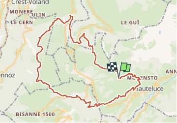
Beaufortain tour des Saisies par grp

taguette
User

Length
25 km

Max alt
1877 m

Uphill gradient
1077 m
Km-Effort
39 km

Min alt
1240 m

Downhill gradient
1078 m
Boucle
Yes
Creation date :
2025-07-27 05:57:00.827
Updated on :
2025-07-27 14:30:41.304
8h33
Difficulty : Very difficult

FREE GPS app for hiking
 SityTrail
IGN / Geographical institutes
SityTrail Plus
The world is yours!
About
Trail Walking of 25 km to be discovered at Auvergne-Rhône-Alpes, Savoy, Hauteluce. This trail is proposed by taguette.
Positioning
Country:
France
Region :
Auvergne-Rhône-Alpes
Department/Province :
Savoy
Municipality :
Hauteluce
Location:
Unknown
Start:(Dec)
Start:(UTM)
310576 ; 5069776 (32T) N.
Comments