


2eme ventoux

mthomas30
User
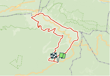

Length
19.1 km

Max alt
1910 m

Uphill gradient
863 m
Km-Effort
31 km

Min alt
1143 m

Downhill gradient
861 m
Boucle
Yes
Creation date :
2025-07-27 08:56:18.646
Updated on :
2025-07-27 18:48:55.449
4h53
Difficulty : Medium

FREE GPS app for hiking
 SityTrail
IGN / Geographical institutes
SityTrail Plus
The world is yours!
About
Trail Walking of 19.1 km to be discovered at Provence-Alpes-Côte d'Azur, Vaucluse, Bédoin. This trail is proposed by mthomas30.
Positioning
Country:
France
Region :
Provence-Alpes-Côte d'Azur
Department/Province :
Vaucluse
Municipality :
Bédoin
Location:
Unknown
Start:(Dec)
Start:(UTM)
684044 ; 4889413 (31T) N.
Comments