


Lac de l'Orceyrette

Clo0413
User
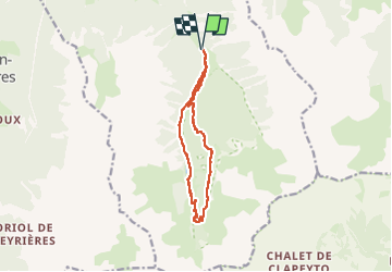

Length
11.6 km

Max alt
2193 m

Uphill gradient
504 m
Km-Effort
18.3 km

Min alt
1710 m

Downhill gradient
503 m
Boucle
Yes
Creation date :
2025-07-27 08:46:19.376
Updated on :
2025-08-05 11:21:03.315
3h18
Difficulty : Medium

FREE GPS app for hiking
 SityTrail
IGN / Geographical institutes
SityTrail Plus
The world is yours!
About
Trail Walking of 11.6 km to be discovered at Provence-Alpes-Côte d'Azur, Hautes-Alpes, Villar-Saint-Pancrace. This trail is proposed by Clo0413.
Positioning
Country:
France
Region :
Provence-Alpes-Côte d'Azur
Department/Province :
Hautes-Alpes
Municipality :
Villar-Saint-Pancrace
Location:
Unknown
Start:(Dec)
Start:(UTM)
314990 ; 4968384 (32T) N.
Comments